There’s something deeply humbling about watching the ocean breathe. The rise and fall of the tide—steady, timeless, and non-negotiable—should be top of mind for any boater. Whether you’re anchoring for lunch or planning a tricky passage, understanding tides isn’t just useful, it’s essential. If you’ve ever tried to beach your dinghy only to return and find it high and dry like a forgotten kayak at a garage sale, this post is for you. Let’s wade into the topic of tides and how they differ from currents. We will break down the science, share some helpful tools, and yes—I’ll even tell you about my beloved tide clock.
As we dive into this topic, remember: What the Tide? A Practical Guide for Boaters is your key to navigating the waters with confidence.
Why Tides Happen
Tides are caused by the gravitational pull of the moon (mostly) and the sun (a bit less, but still important). Imagine the ocean as a vast, mobile blanket being gently tugged by the moon’s gravity. As the Earth spins, these tidal bulges travel across the planet’s surface, resulting in regular rising and falling sea levels.
In most coastal areas, there are two high tides and two low tides every 24 hours and 50 minutes. This is called a semi-diurnal tide cycle, and while it sounds very scientific, it just means the water level changes roughly every six hours. As a boater, this cycle affects everything from where you anchor to whether you can safely navigate that skinny entrance into your favourite cove.
Tide height matters, too. On the West Coast, the tidal range can vary dramatically—up to 15 feet in some places. That means a deep channel at high tide might turn into a barely submerged sandbar at low tide.
The Breakdown:
- The moon’s gravity pulls on the Earth’s water. That creates a bulge (aka high tide).
- The Earth rotates, so that the bulge moves around, like a giant watery hula hoop.
- Meanwhile, the sun joins the party, adding its own pull, especially during full and new moons when you get spring tides (big highs and big lows).
This dance happens roughly every 6 hours and 12 minutes, which is why you get two high tides and two low tides a day (give or take).
- And during quarter moons? You get neap tides. A neap tide is the gentler, quieter cousin of the more dramatic spring tide. It happens twice a month, during the first and third (or last) quarter moons, when the sun and moon are at right angles to each other relative to Earth. Here’s the simplest way to remember it: Neap tide = not much happening. The high tides aren’t very high, and the low tides aren’t very low. The difference between them—called the tidal range—is minimal.

And what is the difference between a Full Moon and a New Moon?
🌕 Full Moon
- The moon is fully illuminated—we see the entire face lit up by the sun.
- It’s on the opposite side of the Earth from the sun, so the Earth is between the two.
- Often brighter nights, ideal for anchoring in open bays or stargazing with your dog.
- Triggers spring tides (also known as high tides and low tides) due to the combined gravitational pull of the sun and moon being in a straight line.
🌑 New Moon
- The moon is invisible to us—the sunlit side is facing away from Earth.
- The moon is positioned between the Earth and the sun.
- Nights are darker (great for spotting phosphorescence in the water).
- Also causes spring tides, just like a full moon, because the sun and moon are aligned, doubling up their gravitational pull.

Tides vs. Currents: Know the Difference
Tides and currents are often confused, but they’re not the same. Tides are the vertical movement of water—up and down—driven by the gravitational forces of the moon and sun. Currents, on the other hand, are the horizontal movement of water—back and forth, or in and out—caused by tides but also by wind, river inflow, and ocean circulation.
You can think of tides as the cause, and tidal currents as one of the effects. When the tide rises or falls, water flows to adjust, creating currents that may help or hinder your travel. This distinction becomes especially important in areas like Seymour Narrows or the Yuculta Rapids, where timing your transit with the slack tide can make the difference between a smooth ride and a white-knuckle adventure.
How Tides Are Local
Tides don’t behave the same way everywhere. Local geography, ocean floor contours, and even weather can affect both the timing and strength of tidal changes. That’s why you can’t just look up “Pacific tides” and call it a day. You need location-specific data, and preferably tools that are easy to interpret.
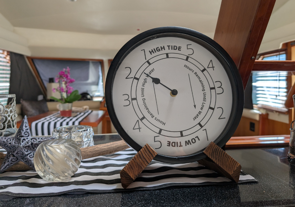
My Tide Clock: An Elegant Companion
One of my favourite onboard tools is my tide clock. Not because it’s digital or high-tech—it’s not—but because it gives me an instant sense of what the tide is doing without scrolling through an app or chasing cell service. It’s analog, stylish, and perfectly suited to any cabin or cockpit wall. I glance at it while I’m making coffee or checking the lines and know exactly where we are in the cycle. It is the perfect quick reference guide while I am at anchor.
The Tide Clock allows you to easily track the high and low tides in your area. Simply set it based on your local tide station.

It’s one of those small additions that make a big difference, especially when anchoring in remote marine parks or timing a dinghy ride to shore.
5 Tide Apps Worth Downloading
My tide clock is a great visual reference, but I have to set it based on reliable data and my GPS location. These are my top five picks:
1. Tides Near Me (Free)
Fast, clean, and no unnecessary extras. It uses your GPS to locate the nearest tide station and displays high/low tides, as well as sunrise/sunset times.
2. AyeTides (Paid)
A more detailed option with offline access—ideal for areas with limited service. Trusted by professional mariners and weekend cruisers alike.
3. Navionics Boating App (Paid)
A full-featured navigation app that includes tide and current data. Great if you’re already using it to chart your route or track weather.
4. My Tide Times (Free and Pro Versions)
Elegant interface with global tide data, moon phases, and the ability to bookmark your favourite locations.
5. Wavve Boating (Free and Pro Versions)
Wavve Boating is a marine navigation app that offers features like real-time routing, crowdsourced location sharing, and simplified charts providing a “Google Maps” experience for boaters..
You can also visit the Canadian Tide Tables website.
Final Wave of Wisdom
Tides aren’t just background noise to a day on the water—they shape it. Understanding how they work, how they differ from currents, and how to track them with both analog and digital tools will make your cruising experience safer, smoother, and far more enjoyable.
Whether you’re threading through rapids, anchoring in a tidal bay, or simply heading ashore for a dog walk at low tide, knowing the tide cycle helps you stay one step ahead. Think of it as part science, part intuition, and part ritual—like checking the weather or giving your boat a little pat before casting off.
Happy cruising,