There are certain things boaters learn to do almost automatically. Check the weather before leaving an anchorage. Look up the current before entering a narrow passage. Add an hour to the tide tables when daylight saving time begins.
That last habit is about to become a little more interesting.
On November 1, 2026, British Columbia will do something we haven’t done before: absolutely nothing. While much of North America turns its clocks back an hour, we’ll leave ours alone. No adjusting the clock in the galley, no resetting the car, and no wondering whether the microwave has been telling the truth for the past six months.
Meanwhile, Washington State will turn its clocks back as usual.
For those of us who cruise between the Gulf Islands and Washington’s San Juan Islands, that means something rather unusual. Two places separated by a short stretch of water will suddenly be living an hour apart. And while the clocks are changing, the tides aren’t paying the slightest attention.
Why British Columbia Is Ending Daylight Saving Time Changes
British Columbia has officially adopted permanent Pacific Time, abbreviated PCT, which is seven hours behind Coordinated Universal Time (UTC−7). Our final clock change happened on March 8, 2026, when we moved forward one hour. On November 1, instead of returning to Pacific Standard Time, we’ll simply stay where we are. The decision wasn’t made overnight. In 2019, the provincial government surveyed more than 223,000 British Columbians, and an overwhelming 93% supported eliminating seasonal clock changes.
The reasons were practical: fewer sleep disruptions, more consistent schedules, and an extra hour of usable evening daylight during winter. Of course, we’re not actually creating more daylight. We’re simply shifting where it falls on the clock. For those who enjoy being outdoors after work, the change is appealing. A little more evening light means more opportunities for walking, gardening, or perhaps getting down to the marina before darkness settles in.
The trade-off is darker winter mornings. The sun will rise an hour later by the clock than it would have under Pacific Standard Time. Children heading to school and commuters leaving early will experience more darkness at the beginning of their day.
It’s an interesting choice about how we prefer to use our daylight.
Why Washington State Is Still Turning Its Clocks Back
Here’s the surprising part: Washington State also wants permanent daylight-saving time. In 2019, Washington lawmakers passed legislation expressing their intention to adopt year-round daylight saving time. Oregon and California have also explored changes to their seasonal time arrangements. But Washington faces a legal obstacle that British Columbia doesn’t.
Under the United States’ federal Uniform Time Act, states can choose to remain on standard time year-round, but they cannot independently adopt permanent daylight-saving time. That requires federal authorization.
British Columbia initially delayed its own change, hoping to coordinate with neighbouring American states. After years of waiting, the province decided to move ahead on its own. As a result, beginning November 1, British Columbia and Washington will no longer share the same wintertime.
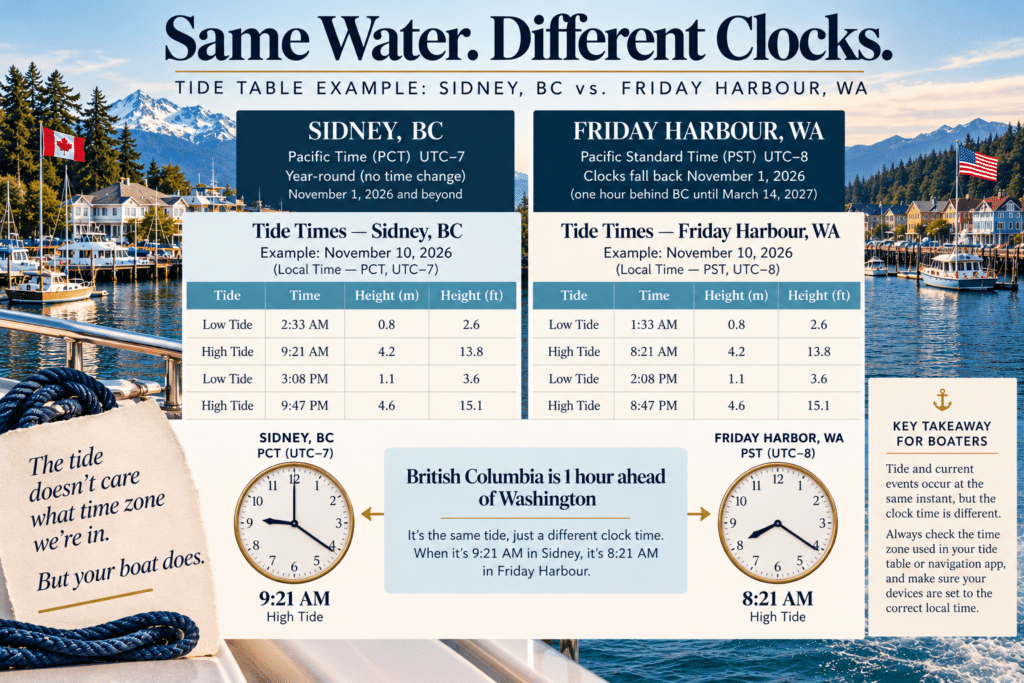
From November until Washington springs forward again on March 14, 2027, British Columbia will be one hour ahead.
When it’s 9:00 a.m. in Vancouver, it will be 8:00 a.m. in Seattle.
For most people, that means remembering the difference when arranging meetings, making reservations or crossing the border. For boaters, it introduces another consideration.
What Does the Time Change Mean for Tide Tables?
Whether we’re navigating a narrow channel, timing our arrival at an anchorage or waiting for slack water, the clock matters. Historically, many printed tide and current tables have used Pacific Standard Time (PST), which is UTC−8. During daylight saving time, when our clocks were an hour ahead, we added an hour to the printed prediction.
A tide listed at 10:00 a.m. PST would occur at 11:00 a.m. on our summer clocks. When the clocks fell back in November, that extra hour was no longer necessary.
Now, with British Columbia remaining on UTC−7 year-round, a table that uses PST will require the same one-hour adjustment year-round. In other words, the calculation becomes more consistent, but it doesn’t necessarily disappear.
Another important detail: not every tide table uses PST. Some digital predictions already display the correct local time, including daylight saving adjustments where applicable. Others allow you to choose the time zone. Before using any prediction, check whether the times are listed in PST, PCT, local time or UTC.
The difference could be an hour, and that’s not something I’d want to discover while approaching a narrow passage with a strong current running against us.
So what happens when you are cruising from Roche Harbour or Friday Harbour to the Gulf Islands?
Imagine spending a few days in Roche Harbour or Friday Harbour before heading north to the Gulf Islands. It’s November, and you’re enjoying a morning coffee while checking the weather, reviewing your route and looking at the tide predictions.
Your watch says 8:00 a.m. because you’re in Washington. Across the border, in British Columbia, it’s already 9:00 a.m.
The water hasn’t changed time zones. Neither have the moon’s gravitational pull nor the currents moving through the channels. But the clocks used to describe those events have changed. Suppose you’re planning your departure around a predicted slack current. If the prediction is displayed in Washington’s local wintertime, 10:00 a.m. PST, that same instant will be 11:00 a.m. PCT in British Columbia.
If you’re looking at a Canadian prediction already displayed in PCT, you wouldn’t add another hour.
The important question is no longer simply, “What time is slack?” It’s “What time zone is that prediction using?”
For cross-border cruising, I think the simplest approach is to choose one time reference for the entire passage. You might use British Columbia’s PCT throughout your trip or convert everything to UTC. Either approach works, as long as you’re consistent.
And remember that the United States and Canada also use different tidal datums for many published water-level predictions. Time conversions and tide heights are separate matters, so always use the appropriate local predictions and chart information.
Why Current Tables Deserve Even More Attention
Tide tables tell us when the water is expected to rise and fall. Current tables predict the horizontal movement of water, including maximum flood, maximum ebb and slack water.
Those aren’t interchangeable.
In the Pacific Northwest, some passages can make or break a trip’s comfort and safety. I’ve experienced that firsthand in the Discovery Islands, where a few knots of current can change the entire character of a passage. An hour’s mistake in interpreting a current table could mean arriving at a narrow channel when the water moves much faster than expected.
That’s why I would never rely on a mental assumption about daylight saving time. I want to know exactly which time standard the prediction uses, and I want my clock time to match my calculations. For our cruising, that means checking the publication notes, verifying the station and confirming the time zone before making a passage plan. It’s a small habit, but an important one.
A Little More Evening Light, and One More Thing to Remember
I rather like the idea of keeping our clocks consistent throughout the year. There’s something appealing about an extra hour of evening light, particularly during those darker months when daylight seems to disappear before we’ve finished everything we wanted to do. But the new arrangement also reminds me how much of boating depends on understanding the systems we use rather than simply following familiar routines.
For years, we’ve adjusted our clocks twice annually and made the corresponding changes to our tide-table calculations. Now the clocks in British Columbia will stay put, while those in Washington will continue moving. The ocean, of course, will carry on exactly as it always has.
And perhaps that’s the most useful reminder of all: the tide doesn’t care what time zone we’re in. But we certainly should.
Will Garmin, Navionics and Electronic Navigation Systems Adjust Automatically?
Fortunately, most of us aren’t sitting at the helm with a pencil, a tide table and a calculator anymore. Modern electronic navigation has made passage planning considerably easier, especially when it comes to predicting tides and currents. But British Columbia’s new time zone raises an interesting question: will our electronics know that we’ve stopped changing our clocks?
The answer is generally yes, provided the software has been updated and the time settings are correct. Systems such as Garmin chart plotters and the Navionics Boating app use GPS information, device settings and software to display time and calculate predictions. However, GPS time and local clock time aren’t the same. GPS provides a consistent time reference, while the navigation system determines how that translates into the time displayed on our screens.
Many Garmin chart plotters let users select automatic time-zone detection or manually set a UTC offset. Navionics also uses device time information when displaying tide and current predictions. The potential complication is that an older system may still assume British Columbia follows the traditional November clock change.
Imagine leaving Friday Harbour at 9:00 a.m. on a November morning. Across the border in Sidney, British Columbia, it’s already 10:00 a.m. An electronic navigation system with current time-zone information should recognize that difference, but a chart plotter using a fixed UTC offset may continue displaying Washington time.
Aboard As You Wish II, we use Garmin electronics and an iPad for additional navigation information. I’ve always appreciated having independent displays, particularly when navigating unfamiliar passages. This November, I’ll be paying particular attention to whether they agree on the time.
Before relying on electronic tide and current predictions, I recommend checking three things:
- that your navigation software is current,
- that your device displays the correct local time and UTC offset,
- and that its predictions agree with an official source such as the Canadian Hydrographic Service (or National Ocean Service (NOS) as part of the National Oceanic and Atmospheric Administration (NOAA) in the USA).
Remember that a correct clock doesn’t automatically guarantee a correct prediction. We still need to select the appropriate tide or current station and understand what the information represents. Electronic navigation has certainly reduced the amount of mental arithmetic required at the helm. But it hasn’t eliminated the need to understand what our instruments are telling us.
And if there’s one thing I’ve learned after more than 30 years of boating, it’s that knowing why a number appears on the screen is every bit as important as knowing what that number says.
Do you prefer the extra evening daylight, or would you rather have brighter winter mornings? And if you cruise between British Columbia and Washington, will the one-hour difference change how you plan your passages?